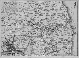
| Title: | Plan of the Rivers Tyne & Wear with the Collieries, Waggon-ways & Staiths, thereon And the Principal Roads & Villages, also a Plan of Newcastle upon Tyne | |
| Creator: | Lambert | |
| Date: | 1807 | |
| Map centred on the River Tyne showing South Northumberland and part of County Durham (from the Tyne to Lanchester, and from the coast to Dipton), showing roads, rivers, woodland, churches and larger residences. Coal mines are marked with shaft depth in fathoms. Staithes on the Tyne and Wear are marked, with faint dotted lines indicating waggon-ways to collieries. Inset, bottom left corner, is a map of Newcastle upon Tyne, with the River Tyne and part of the Gateshead shore, scale approximately 1 inch = 400 yards. | ||
| Retrieve full record | ||
| Title: | North Shields, Northumberland. | 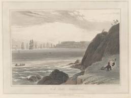 |
| Creator: | Daniell, W. (William), 1769-1837 | |
| Date: | July 1, 1822 | |
| Contents description: chiefly shows North Shields, with prominent lighthouse and the Tyne busy with shipping. South Shields appears more faintly in the distance. With several figures on the foreground rocks. | ||
| Retrieve full record | ||
| Title: | At Shields. Looking East. | 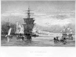 |
| Creator: | Carmichael, J. W. (John Wilson), 1799-1868 | |
| Date: | [ca. 1830] | |
| Contents description: view from South Shields across Peggy's Hole and down river, with small rowing boats filled with people and large sailing ships on the water. Beyond to the left is North Shields and in the far distance just off centre there are the ruins of Tynemouth priory. Originally printed for Carmichael's Views of the Tyne ca. 1830 (reprinted in 1881). | ||
| Retrieve full record | ||
| Title: | North & South Shields, taken from the rocks near Tynemouth. | 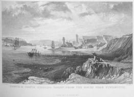 |
| Creator: | Allom, Thomas, 1804-1872 | |
| Date: | 1832 | |
| Contents description: chiefly shows North Shields, with prominent lighthouse and the Tyne busy with shipping. South Shields appears more faintly in the distance. With three figures, one of them using a telescope, on the foreground rocks. In Thomas Rose's Westmorland, Cumberland, Durham, and Northumberland illustrated, 3 vols.... (London, Paris, 1832-35), vol.1; the lower of two illustrations on the plate facing page 16. | ||
| Retrieve full record | ||
| Title: | Map of the country round Newcastle upon Tyne included in a district of ten miles. | 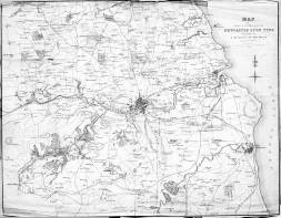 |
| Creator: | Creator not certain | |
| Date: | 1838 | |
| Contents description: map of the country around Newcastle. The Brandling Junction, Stanhope and Tyne, Durham & Sunderland, Durham Junction and the Newcastle and Carlisle railways are all shown, and the rivers Tyne and Wear. | ||
| Retrieve full record | ||
| Title: | Map of the country round Newcastle upon Tyne included in a district of ten miles. | 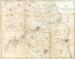 |
| Creator: | Collard, William, 1792-1847 | |
| Date: | [ca. 1838] | |
| Contents description: Shows rivers, railways and major roads. Map also used in Richardson's Handbook to Newcastle (1838). | ||
| Retrieve full record | ||
| Title: | Plan of part of the Newcastle coal district in the county of Northumberland being the third of a series of plans of the Great Northern coal field, | 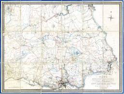 |
| Creator: | Bell, J. T. W. (John Thomas William) | |
| Date: | 1847 | |
| Contents description: indicates the ownership of land, and mineral royalties associated with it. Shows collieries, railway lines, towns, villages, parks and country houses of the gentry, rivers, and roads.
Includes the south bank of the Tyne, showing Gateshead, South Shields, and railways and collieries. | ||
| Retrieve full record | ||
| Title: | Map of the great northern coalfield, in the counties of Northumberland & Durham. Including the whole of the coal mining districts of the Tyne, Wear and Tees, and those of Hartlepool, Seaham, Hartley, Blyth & Warkworth. | 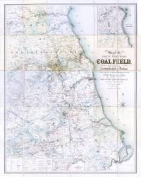 |
| Creator: | Bell, J. T. W. (John Thomas William) | |
| Date: | 1850 | |
| Contents description: detailed map, which distinguishes moors and commons, woodland, and parks, and county, borough, parish and township boundaries, and shows collieries, public and private railways (existing and intended), docks, quarries, castles and country houses, windmills and watermills, etc.
Insets: [1] 'Map shewing the continuation of the Stockton & Darlington Railway by Darlington to Middlesborough and Redcar', scale bar 1� in. approx. = 5 miles, size 82 x 22cm]. [2] 'Continuation of map northwards to Warkworth harbour', scale bar 2 in. approx. = 2 miles, size 25 x 28 cm. | ||
| Retrieve full record | ||
| Title: | Map of the coalfield, of Northumberland & Durham, shewing the ascertained collieries, pits, faults, dykes & other interruptions, with the railways & parts of shipment. | 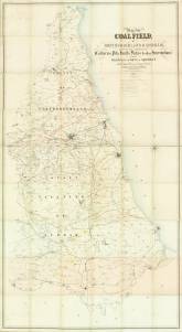 |
| Creator: | Oliver, William | |
| Date: | 1851 | |
| Contents description: map of parts of County Durham and Northumberland (from Warkworth to the Tees, and from the coast west to Wolsingham), showing the outcrop of the coalfields, and areas of magnesian limestone, red sandstone, and red clay. Indicates collieries and railway lines, woodland, country houses and park land. Lithographed. | ||
| Retrieve full record | ||
| Title: | Plan of part of the counties of Durham and Northumberland, shewing the coal field on those counties, by Tho[ma]s. Young Hall, Newcastle upon Tyne. In connection with his treatise on the duration of the said coalfield. 1854. | 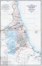 |
| Creator: | Hall, Thomas Young | |
| Date: | 1854 | |
| Contents description: best household coal districts, steam coal districts, coke and coal districts, and districts with various types of coal seams are shown by different colouring. Red spots indicates where the 'Romans worked coal... or where no records have been kept'. Also shows iron works, and, near Guisborough, ironstone mines and alum works. Issued to accompany T.Y. Hall's Treatise on the extent & probable duration of the northern coal field (Newcastle, 1854). | ||
| Retrieve full record | ||
| Title: | Sketch map of the geology & mineralogy of the north of England. | 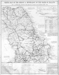 |
| Creator: | Knipe, James A. | |
| Date: | [1860] | |
| Contents description: covers the north of England and part of Scotland. Symbols indicate the distribution of coal, iron, lead, alum and building stone. Marginal notes include a list of blast furnaces in Cleveland, Durham and Northumberland, with the names of their owners. Railways are shown. In W. Fordyce's A history of coal, coke, coal fields... (London, 1860), map preceding title-page. | ||
| Retrieve full record | ||
| Title: | Sketch geological map of the district of country. From the Firth of Forth, Scotland. to the River Tees, England. | 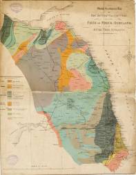 |
| Creator: | Reid, Andrew, 1823-1896 | |
| Date: | [186-?] | |
| Contents description: geological map of the north-east of England, and the south-east of Scotland, showing, in colour, the geological areas. Also indicates railway lines, towns, and coal fields. | ||
| Retrieve full record | ||
 Timestamp: 03/07/2025 04:59:49