 m0110
m0110Additional scale information: [Scale bar: 7ľ in. = 50 miles]
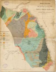
| Title: | Sketch geological map of the district of country. From the Firth of Forth, Scotland. to the River Tees, England. | m0110 | ||||||||
| Creator (as stated on item): | Lithographed in colors [sic], by Andrew Reid, Newcastle. | |||||||||
| Place of publication: | [Newcastle upon Tyne] | |||||||||
| Date of publication: | [186-?] | MMM | ||||||||
| Contents description: geological map of the north-east of England, and the south-east of Scotland, showing, in colour, the geological areas. Also indicates railway lines, towns, and coal fields. | ||||||||||
| Scale [ca. 1:422 400] Additional scale information: [Scale bar: 7ľ in. = 50 miles] | ||||||||||
| Quantity/type of material: | 1 map | |||||||||
| Size: | 48 x 39 cm | |||||||||
| Other information | col. | |||||||||
Copies held (with reference number and copy specific notes)
Please note that when a print occurs in a published book, only one occurence of that book amongst the partners is recorded. Other copies may exist, and can be located via the book catalogue for the institution. This does not apply to albums or to loose copies, where each instance of the print is given.
| Repository/reference number: | DCO Maps DU/A38 | |
| Copy specific notes: | Mounted on linen. Borders cropped. | |
Index Terms
| People | ||
| Creator: | Reid, Andrew, 1823-1896 | |
| Places | |
| Durham (England : County) - Maps, General - 186-? | |
| Northumberland (England) - Maps - 186-? | |
| Subjects | |
| Geology - Maps | |
 Timestamp: 19/06/2026 20:56:35 Record number: 534