 m0079
m0079Lithographed.
Additional scale information: Scale statement on map: 1 Ľ inch to 1 mile
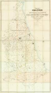
| Title: | Map of the coalfield, of Northumberland & Durham, shewing the ascertained collieries, pits, faults, dykes & other interruptions, with the railways & parts of shipment. | m0079 | ||||||||
| Creator (as stated on item): | Constructed for the coal trade, by William Oliver, mining engineer, Walbottle, Newcastle, with the assistance of other mining engineers of the district. 1851. M. &. M.W. Lambert, lithographers | |||||||||
| Place of publication: | Newcastle | |||||||||
| Other publication given: | M. & M.W. Lambert, lithographers | |||||||||
| Date of publication: | 1851 | MMM | ||||||||
| Contents description: map of parts of County Durham and Northumberland (from Warkworth to the Tees, and from the coast west to Wolsingham), showing the outcrop of the coalfields, and areas of magnesian limestone, red sandstone, and red clay. Indicates collieries and railway lines, woodland, country houses and park land. Lithographed. | ||||||||||
| Scale [1:50 688] Additional scale information: Scale statement on map: 1 Ľ inch to 1 mile | ||||||||||
| Quantity/type of material: | 1 map | |||||||||
| Size: | 203 x 107 cm | |||||||||
| Other information | col. | |||||||||
| Published description: | Turner (1954) 116 | (Bibliography) | ||||||||
Copies held (with reference number and copy specific notes)
Please note that when a print occurs in a published book, only one occurence of that book amongst the partners is recorded. Other copies may exist, and can be located via the book catalogue for the institution. This does not apply to albums or to loose copies, where each instance of the print is given.
| Repository/reference number: | DUL XL 553.2 OLI (accession 18,470) | |
| Copy specific notes: | Dissected, mounted and folded to 24 x 20 cm, in case 26 x 21 cm. | |
| Repository/reference number: | DCO Maps (accession 451672) | |
| Copy specific notes: | Folded to 36 x 20 cm, in boards 37 x 21 cm, with armorial bookplate of Matthew Liddell. Hand col. | |
Index Terms
| People | ||
| Creator: | Oliver, William | |
| Corporate bodies | ||
| Creator: | M. & M. W. Lambert (Lithographers) | |
| Places | |
| Durham (England : County) - Maps, Smaller areas - 1851 | |
| Northumberland (England) - Maps - 1851 | |
| Subjects | |
| Coal mines and mining - Maps | |
 Timestamp: 24/06/2026 13:35:39 Record number: 98