 m0155
m0155In W. Fordyce's A history of coal, coke, coal fields... (London, 1860), map preceding title-page.
Additional scale information: Scale statement on map: 12 miles to 1 inch
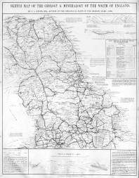
| Title: | Sketch map of the geology & mineralogy of the north of England. | m0155 | ||||||||
| Creator (as stated on item): | By J.A. Knipe, Esq[uire] | |||||||||
| Place of publication: | Newcastle | |||||||||
| Other publication given: | published by W. Fordyce | |||||||||
| Date of publication: | [1860] | MMM | ||||||||
| Contents description: covers the north of England and part of Scotland. Symbols indicate the distribution of coal, iron, lead, alum and building stone. Marginal notes include a list of blast furnaces in Cleveland, Durham and Northumberland, with the names of their owners. Railways are shown. In W. Fordyce's A history of coal, coke, coal fields... (London, 1860), map preceding title-page. | ||||||||||
| Scale [1:760 320] Additional scale information: Scale statement on map: 12 miles to 1 inch | ||||||||||
| Quantity/type of material: | 1 map | |||||||||
| Size: | 50 x 39 cm | |||||||||
Copies held (with reference number and copy specific notes)
Please note that when a print occurs in a published book, only one occurence of that book amongst the partners is recorded. Other copies may exist, and can be located via the book catalogue for the institution. This does not apply to albums or to loose copies, where each instance of the print is given.
| Repository/reference number: | DUL XLL 622.3 FOR | |
Index Terms
| People | ||
| Creator: | Knipe, James A. | |
| Places | |
| Durham (England : County) - Maps, General - 1860 | |
| Northumberland (England) - Maps - 1860 | |
| Cumberland (England) - Maps - 1860 | |
| Yorkshire (England) - Maps - 1860 | |
| Subjects | |
| Geology - Maps | |
| Mines and mining resources | |
| Railways - Maps | |
 Timestamp: 16/06/2026 06:04:02 Record number: 489