 m0008
m0008Additional scale information: [Scale bar: 5 in. = 5 statute miles]
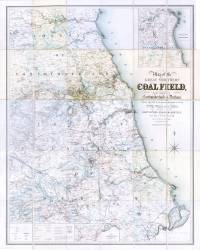
| Title: | Map of the great northern coalfield, in the counties of Northumberland & Durham. Including the whole of the coal mining districts of the Tyne, Wear and Tees, and those of Hartlepool, Seaham, Hartley, Blyth & Warkworth. | m0008 | ||||||||
| Creator (as stated on item): | From actual survey by I.T.W. Bell, engraved by M. & M.W. Lambert. | |||||||||
| Place of publication: | Newcastle upon Tyne | |||||||||
| Date of publication: | 1850 | MMM | ||||||||
| Contents description: detailed map, which distinguishes moors and commons, woodland, and parks, and county, borough, parish and township boundaries, and shows collieries, public and private railways (existing and intended), docks, quarries, castles and country houses, windmills and watermills, etc.
Insets: [1] 'Map shewing the continuation of the Stockton & Darlington Railway by Darlington to Middlesborough and Redcar', scale bar 1˝ in. approx. = 5 miles, size 82 x 22cm]. [2] 'Continuation of map northwards to Warkworth harbour', scale bar 2 in. approx. = 2 miles, size 25 x 28 cm. | ||||||||||
| Scale [1:63 360]] Additional scale information: [Scale bar: 5 in. = 5 statute miles] | ||||||||||
| Quantity/type of material: | 1 map | |||||||||
| Size: | 114 x 89 cm | |||||||||
| Other information | col. | |||||||||
| Published description: | Turner (1954) 115 | (Bibliography) | ||||||||
Copies held (with reference number and copy specific notes)
Please note that when a print occurs in a published book, only one occurence of that book amongst the partners is recorded. Other copies may exist, and can be located via the book catalogue for the institution. This does not apply to albums or to loose copies, where each instance of the print is given.
| Repository/reference number: | DUL XL 553.2 BEL (accession 96,709) | |
| Copy specific notes: | Dissected, mounted and folded to 26 x 17 cm, in boards 27 x 19 cm. | |
| Repository/reference number: | DCO Maps (accession 628775) | |
| Copy specific notes: | On linen, folded to 19 x 12 cm, in case 20 x 12 cm. Not coloured. | |
Index Terms
| People | ||
| Creator: | Bell, J. T. W. (John Thomas William) | |
| Corporate bodies | ||
| Creator: | M. & M. W. Lambert (Lithographers) | |
| Places | |
| Durham (England : County) - Maps, Smaller areas - 1850 | |
| Northumberland (England) - Maps - 1850 | |
| Subjects | |
| Coal mines and mining - Maps | |
 Timestamp: 24/06/2026 13:34:59 Record number: 97