 p2681
p2681Additional scale information: [Scale bar: 3 2/3 in. = 5 miles]
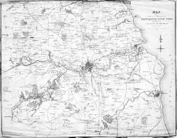
| Title: | Map of the country round Newcastle upon Tyne included in a district of ten miles. | p2681 | ||||||||
| Creator (as stated on item): | Creator information not given on item | |||||||||
| Place of publication: | Newcastle | |||||||||
| Other publication given: | Published by M.A. Richardson, 101 Pilgrim Street. | |||||||||
| Date of publication: | 1838 | MMM | ||||||||
| Contents description: map of the country around Newcastle. The Brandling Junction, Stanhope and Tyne, Durham & Sunderland, Durham Junction and the Newcastle and Carlisle railways are all shown, and the rivers Tyne and Wear. | ||||||||||
| Scale indeterminable. Additional scale information: [Scale bar: 3 2/3 in. = 5 miles] | ||||||||||
| Quantity/type of material: | 1 map : engraving | |||||||||
| Size: | Image: 35 x 45 cm. | |||||||||
Copies held (with reference number and copy specific notes)
Please note that when a print occurs in a published book, only one occurence of that book amongst the partners is recorded. Other copies may exist, and can be located via the book catalogue for the institution. This does not apply to albums or to loose copies, where each instance of the print is given.
| Repository/reference number: | NLM TWCMS: J3274 LAING PRINT BOX 1 | |
| Copy specific notes: | Loose copy. Torn around edges and along folds. On reverse in pencil '84-1583'. | |
Index Terms
| Places | |
| Durham (England : County) - Maps - 1838 | |
| Northumberland (England) - Maps - 1838 | |
| Subjects | |
| Railways - Maps | |
 Timestamp: 24/06/2026 13:38:07 Record number: 2530