 m0185
m0185Additional scale information: [Scale bar: 5/8 in. = 1 mile]
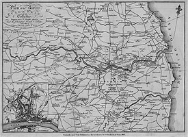
| Title: | Plan of the Rivers Tyne & Wear with the Collieries, Waggon-ways & Staiths, thereon And the Principal Roads & Villages, also a Plan of Newcastle upon Tyne | m0185 | ||||||||
| Creator (as stated on item): | Lambert sculpt. | |||||||||
| Place of publication: | Newcastle upon Tyne | |||||||||
| Other publication given: | published as the Act directs by D. Akenhead & Sons | |||||||||
| Date of publication: | 1807 | MMM | ||||||||
| Map centred on the River Tyne showing South Northumberland and part of County Durham (from the Tyne to Lanchester, and from the coast to Dipton), showing roads, rivers, woodland, churches and larger residences. Coal mines are marked with shaft depth in fathoms. Staithes on the Tyne and Wear are marked, with faint dotted lines indicating waggon-ways to collieries. Inset, bottom left corner, is a map of Newcastle upon Tyne, with the River Tyne and part of the Gateshead shore, scale approximately 1 inch = 400 yards. | ||||||||||
| Scale indeterminable Additional scale information: [Scale bar: 5/8 in. = 1 mile] | ||||||||||
| Quantity/type of material: | 1 map | |||||||||
| Size: | 42.5 cm x 31 cm | |||||||||
Copies held (with reference number and copy specific notes)
Please note that when a print occurs in a published book, only one occurence of that book amongst the partners is recorded. Other copies may exist, and can be located via the book catalogue for the institution. This does not apply to albums or to loose copies, where each instance of the print is given.
| Repository/reference number: | DUL Clayton & Gibson Bute/J/15 | |
Index Terms
| People | ||
| Creator: | Lambert | |
| Corporate bodies | ||
| Creator: | D. Akenhead & Sons | |
| Places | |
| Northumberland (England) - Maps - 1807 | |
| Durham (England : County) - Maps, Smaller areas - 1807 | |
| Newcastle upon Tyne - Maps - 1807 | |
| Subjects | |
| Coal mines and mining - Maps | |
| Railways - Maps | |
 Timestamp: 24/06/2026 13:38:01 Record number: 1808