 m0092
m0092Additional scale information: [Scale bar: 5 in. = 2 statute miles]
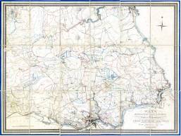
| Title: | Plan of part of the Newcastle coal district in the county of Northumberland being the third of a series of plans of the Great Northern coal field, | m0092 | ||||||||
| Creator (as stated on item): | most respectfully and with his permission dedicated to George Stephenson Esq[ui]r[e] engineer. By his most obedient humble servant. John Thomas William Bell, engineer & surveyor, Newcastle upon Tyne, 1847. | |||||||||
| Place of publication: | Newcastle | |||||||||
| Date of publication: | 1847 | MMM | ||||||||
| Contents description: indicates the ownership of land, and mineral royalties associated with it. Shows collieries, railway lines, towns, villages, parks and country houses of the gentry, rivers, and roads.
Includes the south bank of the Tyne, showing Gateshead, South Shields, and railways and collieries. | ||||||||||
| Scale [ca. 1:158 400] Additional scale information: [Scale bar: 5 in. = 2 statute miles] | ||||||||||
| Quantity/type of material: | 1 map | |||||||||
| Size: | 76 x 105 cm, folded to 28 x 19 cm, in slipcase 29 x 20 cm | |||||||||
| Other information | hand col. | |||||||||
| Series: | Plans of the great northern coal field, 3 | |||||||||
| Published description: | Turner (1954) 150 | (Bibliography) | ||||||||
Copies held (with reference number and copy specific notes)
Please note that when a print occurs in a published book, only one occurence of that book amongst the partners is recorded. Other copies may exist, and can be located via the book catalogue for the institution. This does not apply to albums or to loose copies, where each instance of the print is given.
| Repository/reference number: | DUL XLL 553.2 BEL (accession 91,332) | |
| Copy specific notes: | Dissected, mounted on linen, in slipcase. Title on cover: Royalty plan 3rd series. | |
| Repository/reference number: | DCO Maps (accession 411911) | |
| Copy specific notes: | Map 77 x 102 cm dissected, mounted on linen, folded to 28 x 17 cm, in boards 29 x 18 cm. Title on cover: Royalty plan 3rd series. | |
Index Terms
| People | ||
| Creator: | Bell, J. T. W. (John Thomas William) | |
| Places | |
| Durham (England : County) - Maps, General - 1847 | |
| Northumberland (England) - Maps - 1847 | |
| Subjects | |
| Coal mines and mining - Maps | |
| Land tenure - Maps | |
| Rivers - Maps | |
| Railways - Maps | |
 Timestamp: 24/06/2026 13:35:57 Record number: 445