 p1842
p1842Map also used in Richardson's Handbook to Newcastle (1838).
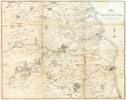
| Title: | Map of the country round Newcastle upon Tyne included in a district of ten miles. | p1842 | ||||||||
| Creator (as stated on item): | Engraved by W. Collard. | |||||||||
| Place of publication: | [Newcastle] | |||||||||
| Date of publication: | [ca. 1838] | MMM | ||||||||
| Contents description: Shows rivers, railways and major roads. Map also used in Richardson's Handbook to Newcastle (1838). | ||||||||||
| [Scale bar: 4 in. = 3 miles] | ||||||||||
| Quantity/type of material: | 1 map | |||||||||
| Size: | 37 x 46 cm | |||||||||
Copies held (with reference number and copy specific notes)
Please note that when a print occurs in a published book, only one occurence of that book amongst the partners is recorded. Other copies may exist, and can be located via the book catalogue for the institution. This does not apply to albums or to loose copies, where each instance of the print is given.
| Repository/reference number: | DUL XL912.4282 | |
Index Terms
| People | ||
| Creator: | Collard, William, 1792-1847 | |
| Places | |
| Newcastle upon Tyne - Maps - 1838 | |
| Northumberland (England) - Maps - 1838 | |
| Durham (England : County) - Maps - 1838 | |
 Timestamp: 24/06/2026 13:39:08 Record number: 2588