 m0128
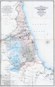
m0128Issued to accompany T.Y. Hall's Treatise on the extent & probable duration of the northern coal field (Newcastle, 1854).
Additional scale information: Scale statement on map: 1/2 in. to a mile
| Title: | Plan of part of the counties of Durham and Northumberland, shewing the coal field on those counties, by Tho[ma]s. Young Hall, Newcastle upon Tyne. In connection with his treatise on the duration of the said coalfield. 1854. | m0128 | ||||||||
| Creator (as stated on item): | By Tho[ma]s Young Hall, M. & M. W. Lambert, lithographers | |||||||||
| Place of publication: | Newcastle | |||||||||
| Date of publication: | 1854 | MMM | ||||||||
| Contents description: best household coal districts, steam coal districts, coke and coal districts, and districts with various types of coal seams are shown by different colouring. Red spots indicates where the 'Romans worked coal... or where no records have been kept'. Also shows iron works, and, near Guisborough, ironstone mines and alum works. Issued to accompany T.Y. Hall's Treatise on the extent & probable duration of the northern coal field (Newcastle, 1854). | ||||||||||
| Scale [1:126 720] Additional scale information: Scale statement on map: 1/2 in. to a mile | ||||||||||
| Quantity/type of material: | 1 map | |||||||||
| Size: | 80 x 51 cm | |||||||||
| Other information | col. | |||||||||
Copies held (with reference number and copy specific notes)
Please note that when a print occurs in a published book, only one occurence of that book amongst the partners is recorded. Other copies may exist, and can be located via the book catalogue for the institution. This does not apply to albums or to loose copies, where each instance of the print is given.
| Repository/reference number: | DUL NSR Planfile C 17/4 | |
| Repository/reference number: | DCO Maps +DU/A12 | |
| Copy specific notes: | Another copy. | |
Index Terms
| People | ||
| Creator: | Hall, Thomas Young | |
| Corporate bodies | ||
| Creator: | M. & M. W. Lambert (Lithographers) | |
| Places | |
| Durham (England : County) - Maps, Smaller areas - 1854 | |
| Northumberland (England) - Maps - 1854 | |
| Subjects | |
| Coal mines and mining - Maps | |
 Timestamp: 24/06/2026 13:35:30 Record number: 93