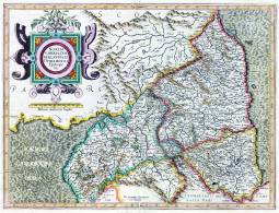
From G. Mercator and J. Hondius, Atlas or a geographicke description... of the world (Amsterdam, H. Hondius & J. Jansson, 1595).
| Title: | Northumbria, Cumberlandia, et Dunelmensis episcopatus. | |
| Creator: | Mercator, Gerhard, 1512-1594 | |
| Date: | [1595] | |
| Contents description: map of Northumberland, Cumberland and Durham county, showing towns, villages, parks and castles, rivers and hills, but not roads. The Roman Wall is shown. County boundaries, parks and hills coloured. Title in a cartouche... Descriptive text on verso in Latin. Engraved centre bottom: 'Per Gerardum Mercatorem Cum Privilegio'.
Scale bar unit of measurement descibed on map as ' Milliaria mediocria Angliae'. From G. Mercator and J. Hondius, Atlas or a geographicke description... of the world (Amsterdam, H. Hondius & J. Jansson, 1595). | ||
| Retrieve full record | ||
| Title: | Northumbria, Cumberlandia, et Dunelmensis episcopatus. | 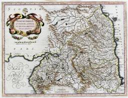 |
| Creator: | Mercator, Gerhard, 1512-1594 | |
| Date: | [1636] | |
| Contents description: map of Northumberland, Cumberland and Durham county, showing towns, villages, parks and castles, rivers and hills, but not roads. The Roman Wall is shown. County boundaries, parks and hills coloured. Title in a cartouche... Descriptive text on verso in English.
Bar scale unit described on map as 'Milliaria mediocriae Anglicae'. From G. Mercator and J. Hondius, Atlas or a geographicke description... of the world (Amsterdam, H. Hondius & J. Jansson, 1636). Reprint of Mercator's map first published in 1595, with new cartouche and scale, Mercator's signature deleted, and sea shading removed. | ||
| Retrieve full record | ||
| Title: | The continuation of the road from London to Barwick, beginning at Chester in ye: Street in Epatu Dunelm & extending to Barwick plate the 5 and last containing 70 ˝ m: vizt: to Newcastle:8: to Morpeth: 15: to Alnwick: 18˝: to Belford:13˝:&:to Barwick:15˝. | 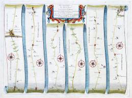 |
| Creator: | Ogilby, John, 1600-1676 | |
| Date: | [1675] | |
| Contents description: road map laid out in 6 strips, showing the main road north from Chester-le-Street to Berwick, with the principal towns, cross roads and rivers along the way. Distances from London are indicated. A hedged road is indicated by two continuous lines, and an open common by two dotted lines. Top centre engraved, the title in an oblong in an ornamental cartouche. Plate 10, from J. Ogilby's Britannia (London, 1675, reprinted 1698). In the 1675 ed. this is plate 9, numbered in the bottom right corner. | ||
| Retrieve full record | ||
| Title: | The road from Whitby in Com. Ebor. to Durham... containing 56 miles 6 furlongs vizt. From Whitby to Skallingdam 11'7. to Gisbourgh 10'0. to Marton 6'7 to Norton 8'4.to Sedgfield 8'1.to Durham 11'3. Thence continued to Tinmouth.in Com Northumbr. 22'4.vizt. From Durham.to Sunderland.13.to Tinmouth 9'4. | 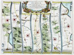 |
| Creator: | Ogilby, John, 1600-1676 | |
| Date: | [1675] | |
| Contents description: road map laid out in 7 strips, showing the main road north from Whitby to Tynmouth, with the principal towns, cross roads and rivers along the way. Distances from London are indicated. A hedged road is indicated by two continuous lines, and an open common by two dotted lines. Top centre engraved, the title in an ornamental cartouche. Plate 101, from J. Ogilby's Britannia (London, 1675, reprinted 1698). In the 1675 edition this is plate 99, and the plate number is given in the bottom right) | ||
| Retrieve full record | ||
| Title: | The road from London to Barwick actually surveyed. | 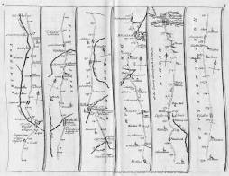 |
| Creator: | Senex, John, fl. 1700-1740 | |
| Date: | [1719] | |
| Contents description: road map laid out in 6 strips per page on a total of five pages, showing the main road north from London to Berwick, with the principal towns, cross roads and rivers along the way. Distances from London are indicated. A hedged road is indicated by two continuous lines, and an open common by two dotted lines. Top centre of first page engraved, the title in a rectangle. Explanatory text is engraved beneath each map. More information and directions are engraved in text in the last two strips of the last map. Page numbers engraved in upper corners. Less ornate and reduced in size version of Ogilby's road maps, published by Senex in 1719. | ||
| Retrieve full record | ||
| Title: | [The road from Whitby to Durham ...] | 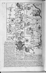 |
| Creator: | Ogilby, John, 1600-1676 | |
| Date: | [1720] | |
| Contents description: road map from Stockton to Tynemouth, with arms of the deanery of Durham. Published in Britannia depicta or Ogilby improv'd ... by John Owen and Emanuel Bowen (London, 1720), p. 270. Reduced in size, derived from Ogilby (1675) plate 99. | ||
| Retrieve full record | ||
| Title: | [The road from London to Barwik ...] | 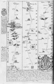 |
| Creator: | Ogilby, John, 1600-1676 | |
| Date: | [1720] | |
| Contents description: road map from Chester-le-Street to Felton, with arms of the Duke of Newcastle. Published in Britannia depicta or Ogilby improv'd ... by John Owen and Emanuel Bowen (London, 1720), p. 20. Reduced in size, derived from Ogilby (1675) plate 8. | ||
| Retrieve full record | ||
| Title: | A map of the meetings, belonging to the quarterly meetings of Lancaster, Westmoreland, Cumberland, Northumberland, Durham & York. | 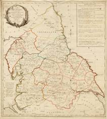 |
| Creator: | Backhouse, J. (James) | |
| Date: | March 1st. 1773 | |
| Contents description: map showing in colour the boundaries of the Monthly Meeting divisions of the Society of Friends in the northern counties. Text engraved on the map gives details of when and where the Monthly Meetings in each county were held, and of the rotation between counties of the Yearly Meeting for the northern counties. Also gives information on Weekly Meeting days, and market days, and shows roads, and distances between places. | ||
| Retrieve full record | ||
| Title: | Plan of the collieries on the rivers Tyne and Wear, also Blyth, Bedlington and Hartley; with the country 11 miles round Newcastle, | 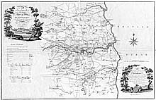 |
| Creator: | Gibson, John | |
| Date: | Jan[uar]y 1st., 1788 | |
| Contents description: map of the Northumberland and Durham coalfield from Bedlington in the north to Wilton Gilbert in the south, and from the coast to Belsay and Ovingham in the west. Indicates depths of coal pits and distances. Waggonways from collieries to staithes are marked in red. Also glassworks and saltpans on the Tyne are shown. Shows parks and houses of nobility and gentry, with names of their owners.
Title vignette (top left) depicts coal staithes and a colliery.
Dedicated to Hugh, Duke of Northumberland, in a vignette (bottom left) depicting Alnwick Castle.
Tables of keel dues on the Tyne and at Sunderland in the margin. Title includes the date '1787' instead of 1788. | ||
| Retrieve full record | ||
| Title: | Plan of the collieries on the rivers Tyne and Wear, also Blyth, Bedlington and Hartley; with the country 11 miles round Newcastle | 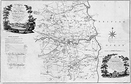 |
| Creator: | Gibson, John | |
| Date: | [1788] | |
| Contents description: map of the Northumberland and Durham coalfield from Bedlington in the north to Witton Gilbert in the south, and from the coast to Belsay and Ovingham in the west. Indicates depths of coal pits and distances. Wagonways from collieries to staithes are marked in red. Also glassworks and saltpans on the Tyne are shown. Shows parks and houses of nobility and gentry, with names of their owners.
Title vignette (top left) depicts coal staithes and a colliery.
Dedicated to Hugh, Duke of Northumberland, in a vignette (bottom left) depicting Alnwick Castle.
Tables of keel dues on the Tyne and at Sunderland in the margin. | ||
| Retrieve full record | ||
| Title: | North & South Shields. | 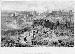 |
| Creator: | Carmichael, J. W. (John Wilson), 1799-1868 | |
| Date: | [before 1847] | |
| Contents description: view of North and South Shields from the North Shields bank of the River Tyne, showing sailing ships in the river and docked along the shoreline. Two lighthouses shown in background. People in foreground watching the ships and walking along the shore. | ||
| Retrieve full record | ||
| Title: | Entrance to Shields Harbour. | 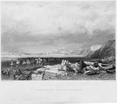 |
| Creator: | Balmer, G. (George), 1805-1846 | |
| Date: | [18--] | |
| Contents description: view of North and South Shields, showing sailing ships coming into the entrance of the harbour, from the North Shields bank of the Tyne. Two lighthouses in mid-ground. People in foreground wading in the water, fishing with nets. Horse and rider amongst the people. Three women with large baskets waiting for people who are fishing. | ||
| Retrieve full record | ||
 Timestamp: 27/07/2024 09:50:26