| | | | | | | | | | |
| Title: | The road from Whitby in Com. Ebor. to Durham... containing 56 miles 6 furlongs vizt. From Whitby to Skallingdam 11'7. to Gisbourgh 10'0. to Marton 6'7 to Norton 8'4.to Sedgfield 8'1.to Durham 11'3. Thence continued to Tinmouth.in Com Northumbr. 22'4.vizt. From Durham.to Sunderland.13.to Tinmouth 9'4. | 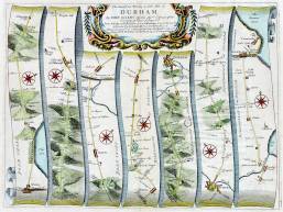 m0163 m0163 |
| Creator (as stated on item): | By John Ogilby Esqr: his Maties: Cosmographer |
| Place of publication: | [London] |
| Other publication given: | [printed by the author at his house in White-Fryers. |
| Date of publication: | [1675] | MMM |
Contents description: road map laid out in 7 strips, showing the main road north from Whitby to Tynmouth, with the principal towns, cross roads and rivers along the way. Distances from London are indicated. A hedged road is indicated by two continuous lines, and an open common by two dotted lines. Top centre engraved, the title in an ornamental cartouche.
Plate 101, from J. Ogilby's Britannia (London, 1675, reprinted 1698). In the 1675 edition this is plate 99, and the plate number is given in the bottom right) | |
| Scale indeterminable |
| Quantity/type of material: | 1 map |
| Size: | 34 x 46 cm |
| Other information | hand col. |
| Published description: | Chubb (1927) C | (Bibliography) |
 Timestamp: 08/07/2026 21:40:01 Record number: 830