 m0159
m0159From G. Mercator and J. Hondius, Atlas or a geographicke description... of the world (Amsterdam, H. Hondius & J. Jansson, 1595).
Additional scale information: [Scale bar: 3Ľ in. = 20 miles]
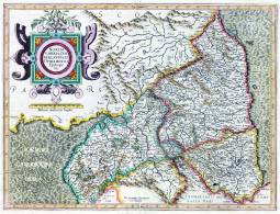
| Title: | Northumbria, Cumberlandia, et Dunelmensis episcopatus. | m0159 | ||||||||
| Creator (as stated on item): | [By G. Mercator] | |||||||||
| Place of publication: | [Amsterdam] | |||||||||
| Date of publication: | [1595] | MMM | ||||||||
| Contents description: map of Northumberland, Cumberland and Durham county, showing towns, villages, parks and castles, rivers and hills, but not roads. The Roman Wall is shown. County boundaries, parks and hills coloured. Title in a cartouche... Descriptive text on verso in Latin. Engraved centre bottom: 'Per Gerardum Mercatorem Cum Privilegio'.
Scale bar unit of measurement descibed on map as ' Milliaria mediocria Angliae'. From G. Mercator and J. Hondius, Atlas or a geographicke description... of the world (Amsterdam, H. Hondius & J. Jansson, 1595). | ||||||||||
| Scale indeterminable Additional scale information: [Scale bar: 3Ľ in. = 20 miles] | ||||||||||
| Quantity/type of material: | 1 map | |||||||||
| Size: | 33 x 45 cm | |||||||||
| Other information | hand col. | |||||||||
| Published description: | Skelton (1970) p. 220-22 | (Bibliography) | ||||||||
Copies held (with reference number and copy specific notes)
Please note that when a print occurs in a published book, only one occurence of that book amongst the partners is recorded. Other copies may exist, and can be located via the book catalogue for the institution. This does not apply to albums or to loose copies, where each instance of the print is given.
| Repository/reference number: | DCO Maps +DU/A1 (accession D89307) | |
Index Terms
| People | |||
| Creator: | Mercator, Gerhard, 1512-1594 | ||
| Other contributor: | Hondius, Jodocus, 1563-1612 | ||
| Places | |
| Durham (England : County) - Maps, General - 1595 | |
| Northumberland (England) - Maps - 1595 | |
| Cumberland (England) - Maps - 1595 | |
 Timestamp: 08/07/2026 21:40:34 Record number: 826