 p2322a
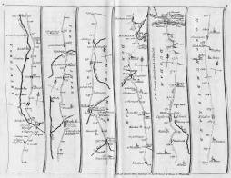
Page numbers engraved in upper corners. Less ornate and reduced in size version of Ogilby's road maps, published by Senex in 1719.
| Title: | The road from London to Barwick actually surveyed. |  p2322a p2322a | ||||||||
| Subtitle: | Containing from London to [list of places through to] Barwick 340. | |||||||||
| Creator (as stated on item): | I. Senex sculp[to]r. | |||||||||
| Place of publication: | [London] | |||||||||
| Date of publication: | [1719] | MMM | ||||||||
| Contents description: road map laid out in 6 strips per page on a total of five pages, showing the main road north from London to Berwick, with the principal towns, cross roads and rivers along the way. Distances from London are indicated. A hedged road is indicated by two continuous lines, and an open common by two dotted lines. Top centre of first page engraved, the title in a rectangle. Explanatory text is engraved beneath each map. More information and directions are engraved in text in the last two strips of the last map. Page numbers engraved in upper corners. Less ornate and reduced in size version of Ogilby's road maps, published by Senex in 1719. | ||||||||||
| Scale indeterminable | ||||||||||
| Quantity/type of material: | 5 maps | |||||||||
| Size: | plate mark of each page 16 x 21.5 cm | |||||||||
Copies held (with reference number and copy specific notes)
Please note that when a print occurs in a published book, only one occurence of that book amongst the partners is recorded. Other copies may exist, and can be located via the book catalogue for the institution. This does not apply to albums or to loose copies, where each instance of the print is given.
| Repository/reference number: | SCM TWCMS : C6535 | |
| Copy specific notes: | Loose map with all pages stitched together with cotton thread. | |
Index Terms
| People | ||
| Creator: | Senex, John, fl. 1700-1740 | |
| Places | |
| Durham (England : County) - Maps, Smaller areas - 1719 | |
| Yorkshire (England) - Maps, Smaller areas - 1719 | |
| Northumberland (England) - Maps, Smaller areas - 1719 | |
| Subjects | |
| Roads - Maps | |