 m0183
m0183Additional scale information: Scale statement on map: 6 in. to 6 miles
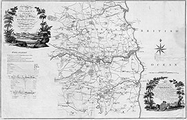
| Title: | Plan of the collieries on the rivers Tyne and Wear, also Blyth, Bedlington and Hartley; with the country 11 miles round Newcastle | m0183 | ||||||||
| Creator (as stated on item): | taken from actual surveys by John Gibson. | |||||||||
| Place of publication: | [s.l.] | |||||||||
| Date of publication: | [1788] | MMM | ||||||||
| Contents description: map of the Northumberland and Durham coalfield from Bedlington in the north to Witton Gilbert in the south, and from the coast to Belsay and Ovingham in the west. Indicates depths of coal pits and distances. Wagonways from collieries to staithes are marked in red. Also glassworks and saltpans on the Tyne are shown. Shows parks and houses of nobility and gentry, with names of their owners.
Title vignette (top left) depicts coal staithes and a colliery.
Dedicated to Hugh, Duke of Northumberland, in a vignette (bottom left) depicting Alnwick Castle.
Tables of keel dues on the Tyne and at Sunderland in the margin. | ||||||||||
| Scale [1:63 360] Additional scale information: Scale statement on map: 6 in. to 6 miles | ||||||||||
| Quantity/type of material: | 1 map | |||||||||
| Size: | 64 x 99 cm | |||||||||
| Published description: | Turner (1954) 149 | (Bibliography) | ||||||||
Copies held (with reference number and copy specific notes)
Please note that when a print occurs in a published book, only one occurence of that book amongst the partners is recorded. Other copies may exist, and can be located via the book catalogue for the institution. This does not apply to albums or to loose copies, where each instance of the print is given.
| Repository/reference number: | DUL NSR Planfile C 22/5 | |
Index Terms
| People | ||
| Creator: | Gibson, John | |
| Places | |
| Durham (England : County) - Maps - 1788 | |
| Northumberland (England) - Maps - 1788 | |
| Subjects | |
| Coal mines and mining - Maps | |
| Coal mines and mining - Pictorial works | |
| Land tenure - Maps | |
| Rivers - Maps | |
 Timestamp: 11/07/2026 01:53:00 Record number: 87