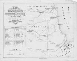
| Title: | Map of the iron districts in Northumberland, Durham and Cleveland. Richard Hoyle, iron merchant, Newcastle upon Tyne, 1860. | |
| Creator: | Hoyle, Richard | |
| Date: | 1860 | |
| Contents description: map of the north-east of England, showing iron furnaces and rolling mills. Also indicates railway lines, towns, and rivers. | ||
| Retrieve full record | ||
| Title: | Map illustrative of a paper on the rivers, ports and harbours of the great northern coal field shewing the facilities of transit possessed by northern coal owners and the benefits that will accrue from the proposed improvements of the River Tyne | 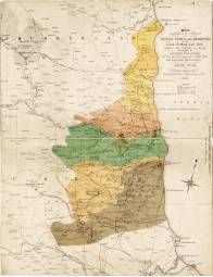 |
| Creator: | Hall, Thomas Young | |
| Date: | [1861] | |
| Contents description: map of the north-east of England from Alnmouth Bay to Redcar, showing, in colour, the geological areas. Also indicates railway lines, collieries, iron works, lead mines and works, towns, and dykes. Published to accompany T.Y. Hall's The river ports and harbours of the great northern coal-field (Newcastle upon Tyne, A. Reid, 1861), a paper which he read at the annual meeting of the North of England Institute of Mining Engineers, July 1861. | ||
| Retrieve full record | ||
| Title: | Plan of the western coal district of Durham and Northumberland, being the sixth of a series of plans of the Great Northern coal field. | 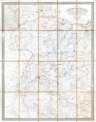 |
| Creator: | Bell, J. T. W. (John Thomas William) | |
| Date: | 1861 | |
| Contents description: indicates the ownership of land, and mineral royalties associated with it. Shows collieries, railway lines, towns, villages, parks and country houses of the gentry, rivers, and roads. | ||
| Retrieve full record | ||
| Title: | Geological map of Northumberland, Durham, & North Yorkshire coloured from a sketch of the geology of the district by Professor Phillips F.R.S. and specially prepared for 'Reid's Hand book to Newcastle'. | 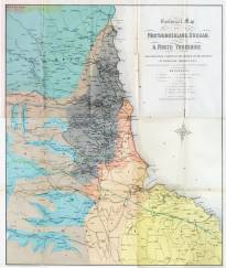 |
| Creator: | Dinning, S. | |
| Date: | [1863] | |
| Contents description: geological map of the north-east of England, showing, in colour, the geological areas. Also indicates railway lines, towns, and coal fields. In J. Collingwood Bruce's A hand-book to Newcastle-on-Tyne. (London, Newcastle, 1863), page 176. | ||
| Retrieve full record | ||
| Title: | Geological map of Northumberland & Durham | 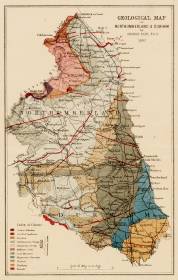 |
| Creator: | Tate, G. (George) | |
| Date: | 1867 | |
| Contents description: map of Durham and Northumberland, showing soil formation for both counties. Indicates roads, cities, rivers and railways. | ||
| Retrieve full record | ||
 Timestamp: 09/07/2025 07:29:39