 m0174
m0174Additional scale information: Scale statement on map: 13 miles to an inch
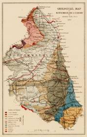
| Title: | Geological map of Northumberland & Durham | m0174 | ||||||||
| Creator (as stated on item): | by George Tate, E.G.S. 1867. | |||||||||
| Place of publication: | [s.l.] | |||||||||
| Date of publication: | 1867 | MMM | ||||||||
| Contents description: map of Durham and Northumberland, showing soil formation for both counties. Indicates roads, cities, rivers and railways. | ||||||||||
| Scale: [1: 823 680] Additional scale information: Scale statement on map: 13 miles to an inch | ||||||||||
| Quantity/type of material: | 1 map | |||||||||
| Size: | 19 x 12 cm | |||||||||
| Other information | hand col. | |||||||||
Copies held (with reference number and copy specific notes)
Please note that when a print occurs in a published book, only one occurence of that book amongst the partners is recorded. Other copies may exist, and can be located via the book catalogue for the institution. This does not apply to albums or to loose copies, where each instance of the print is given.
| Repository/reference number: | DCL Maps 36 | |
Index Terms
| People | ||
| Creator: | Tate, G. (George) | |
| Places | |
| Durham (England : County) - Maps, General - 1867 | |
| Northumberland (England) - Maps - 1867 | |
| Subjects | |
| Geology - Maps | |
 Timestamp: 21/03/2026 13:54:49 Record number: 1139