 p1177
p1177In J. Collingwood Bruce's A hand-book to Newcastle-on-Tyne. (London, Newcastle, 1863), page 176.
Additional scale information: [Scale bar: 2˝ in. = 10 miles]
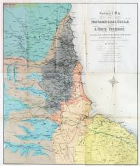
| Title: | Geological map of Northumberland, Durham, & North Yorkshire coloured from a sketch of the geology of the district by Professor Phillips F.R.S. and specially prepared for 'Reid's Hand book to Newcastle'. | p1177 | ||||||||
| Creator (as stated on item): | Engraved & printed by A. Reid, Printing Court Buildings, Newcastle. S. Dinning, land & mine surveyor | |||||||||
| Place of publication: | Newcastle | |||||||||
| Other publication given: | printed by A. Reid, Printing Court Buildings, Newcastle | |||||||||
| Date of publication: | [1863] | MMM | ||||||||
| Contents description: geological map of the north-east of England, showing, in colour, the geological areas. Also indicates railway lines, towns, and coal fields. In J. Collingwood Bruce's A hand-book to Newcastle-on-Tyne. (London, Newcastle, 1863), page 176. | ||||||||||
| Scale [1:253 440] Additional scale information: [Scale bar: 2˝ in. = 10 miles] | ||||||||||
| Quantity/type of material: | 1 map | |||||||||
| Size: | 60 x 51 cm | |||||||||
| Other information | col. | |||||||||
Copies held (with reference number and copy specific notes)
Please note that when a print occurs in a published book, only one occurence of that book amongst the partners is recorded. Other copies may exist, and can be located via the book catalogue for the institution. This does not apply to albums or to loose copies, where each instance of the print is given.
| Repository/reference number: | DUL SC 05632 | |
Index Terms
| People | |||
| Creator: | Dinning, S. | ||
| Other contributor: | Reid, Andrew, 1823-1896 | ||
| Places | |
| Durham (England : County) - Maps, General - 1863 | |
| Northumberland (England) - Maps - 1863 | |
| Yorkshire (England) - Maps, General - 1863 | |
| Subjects | |
| Geology - Maps | |
 Timestamp: 21/03/2026 13:54:50 Record number: 1365