 m0076
m0076Additional scale information: [Scale bar: 2˝ in. = 1 statute mile]
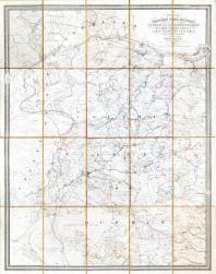
| Title: | Plan of the western coal district of Durham and Northumberland, being the sixth of a series of plans of the Great Northern coal field. | m0076 | ||||||||
| Creator (as stated on item): | By John Thomas William Bell, engineer & surveyor, Newcastle upon Tyne. Eng[rave]d by M. & M.W. Lambert Newcastle on Tyne | |||||||||
| Place of publication: | Newcastle upon Tyne | |||||||||
| Other publication given: | published by M. & M. W. Lambert | |||||||||
| Date of publication: | 1861 | MMM | ||||||||
| Contents description: indicates the ownership of land, and mineral royalties associated with it. Shows collieries, railway lines, towns, villages, parks and country houses of the gentry, rivers, and roads. | ||||||||||
| Scale [1:25 344] Additional scale information: [Scale bar: 2˝ in. = 1 statute mile] | ||||||||||
| Quantity/type of material: | 1 map | |||||||||
| Size: | 101 x 81 cm, folded to 28 x 17 cm, in boards 29 x 18 cm | |||||||||
| Other information | hand col. | |||||||||
| Series: | Plans of the great northern coal field, 6 | |||||||||
Copies held (with reference number and copy specific notes)
Please note that when a print occurs in a published book, only one occurence of that book amongst the partners is recorded. Other copies may exist, and can be located via the book catalogue for the institution. This does not apply to albums or to loose copies, where each instance of the print is given.
| Repository/reference number: | DCO Maps (accession 411914) | |
| Copy specific notes: | Dissected, mounted on linen, in boards. Title on cover: Royalty plan 6th series. | |
Index Terms
| People | ||
| Creator: | Bell, J. T. W. (John Thomas William) | |
| Corporate bodies | ||
| Creator: | M. & M. W. Lambert (Lithographers) | |
| Places | |
| Durham (England : County) - Maps, Smaller areas - 1861 | |
| Northumberland (England) - Maps - 1861 | |
| Subjects | |
| Land tenure - Maps | |
| Coal mines and mining - Maps | |
 Timestamp: 21/03/2026 13:54:51 Record number: 446