 p1618
p1618Additional scale information: Scale statement on map: about 5 miles to an inch
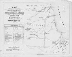
| Title: | Map of the iron districts in Northumberland, Durham and Cleveland. Richard Hoyle, iron merchant, Newcastle upon Tyne, 1860. | p1618 | ||||||||
| Creator (as stated on item): | M. & M.W. Lambert, Newcastle | |||||||||
| Place of publication: | Newcastle | |||||||||
| Date of publication: | 1860 | MMM | ||||||||
| Contents description: map of the north-east of England, showing iron furnaces and rolling mills. Also indicates railway lines, towns, and rivers. | ||||||||||
| Scale [ca. 1:316 800] Additional scale information: Scale statement on map: about 5 miles to an inch | ||||||||||
| Quantity/type of material: | 1 map | |||||||||
| Size: | 20 x 26 cm | |||||||||
Copies held (with reference number and copy specific notes)
Please note that when a print occurs in a published book, only one occurence of that book amongst the partners is recorded. Other copies may exist, and can be located via the book catalogue for the institution. This does not apply to albums or to loose copies, where each instance of the print is given.
| Repository/reference number: | DCL Longstaffe D/MAP | |
Index Terms
| People | ||
| Creator: | Hoyle, Richard | |
| Corporate bodies | ||
| Creator: | M. & M. W. Lambert (Lithographers) | |
| Places | |
| Northumberland (England) - Maps - 1860 | |
| Durham (England : County) - Maps, Smaller areas - 1860 | |
| Yorkshire (England) - Maps - 1860 | |
| Subjects | |
| Railways - Maps | |
| Iron industry and trade - Maps | |
 Timestamp: 21/03/2026 13:54:50 Record number: 1782