| | | | | | | | | | |
| Title: | Map illustrative of a paper on the rivers, ports and harbours of the great northern coal field shewing the facilities of transit possessed by northern coal owners and the benefits that will accrue from the proposed improvements of the River Tyne | 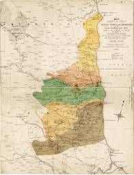 m0111 m0111 |
| Creator (as stated on item): | by Thomas Young Hall, mining engineer, Newcastle on Tyne 1861. |
| Place of publication: | [Newcastle upon Tyne] |
| Date of publication: | [1861] | MMM |
Contents description: map of the north-east of England from Alnmouth Bay to Redcar, showing, in colour, the geological areas. Also indicates railway lines, collieries, iron works, lead mines and works, towns, and dykes.
Published to accompany T.Y. Hall's The river ports and harbours of the great northern coal-field (Newcastle upon Tyne, A. Reid, 1861), a paper which he read at the annual meeting of the North of England Institute of Mining Engineers, July 1861. | |
Scale [1:190 080]
Additional scale information: Scale statement on map: 3 miles to one inch |
| Quantity/type of material: | 1 map |
| Size: | 50 x 38 cm |
| Other information | hand col. |
