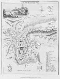
 p2330
p2330Includes the coat of arms for the University of Durham in the upper right hand corner.
Additional scale information: [Scale bar: 1˝ in. = 600 feet]
| Title: | Durham | p2330 | ||||||||
| Creator (as stated on item): | [from a drawing by G. Cole] | |||||||||
| Place of publication: | Durham | |||||||||
| Other publication given: | published by George Andrews | |||||||||
| Date of publication: | January 2nd. 1849 | MMM | ||||||||
| Contents description: map of Durham city, with a vignette of Prebends' Bridge and the cathedral drawn by E. Dayes and engraved by Jos. C. Smith. Prebends' Bridge on the map is in its pre-1772 position. Includes the coat of arms for the University of Durham in the upper right hand corner. | ||||||||||
| Scale [ca. 1:4 800] Additional scale information: [Scale bar: 1˝ in. = 600 feet] | ||||||||||
| Quantity/type of material: | 1 map | |||||||||
| Size: | 23 x 18 cm | |||||||||
Copies held (with reference number and copy specific notes)
Please note that when a print occurs in a published book, only one occurence of that book amongst the partners is recorded. Other copies may exist, and can be located via the book catalogue for the institution. This does not apply to albums or to loose copies, where each instance of the print is given.
| Repository/reference number: | SCM TWCMS : C7896 | |
| Copy specific notes: | Loose map. | |
Index Terms
| People | ||
| Creator: | Cole, G. | |
| Places | |
| Durham City - Maps - 1849 | |
| Subjects | |
| Towns - Maps | |
 Timestamp: 21/04/2026 13:16:13 Record number: 2201